'Cloud-Profiling Radar' wows the crowd
NASA is pretty pleased with the first
pictures beamed back from its CloudSat satellite, which reveal "never-before-seen" 3-D details of clouds, as the press release puts it.
CloudSat - launched on 28 April - carries a millimeter wavelength "Cloud-Profiling Radar" which is "more than 1,000 times more sensitive than typical weather radar" and capable of distinguishing between cloud particles and precipitation. Its main purpose is to "offer new insights into how fresh water is created from water vapor and how much of this water falls to the surface as rain and snow".
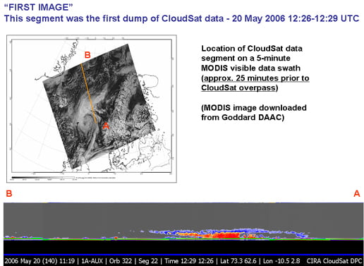
The first data from CloudSat was a representation of a "warm front storm over the Norwegian Sea":

The blurb explains:
CloudSat's first image...was obtained on May 20, 2006. In this horizontal cross-section of clouds, warm air is seen rising over colder air as the satellite travels from right to left. The red colors are indicative of highly reflective particles such as water droplets (or rain) or larger ice crystals (or snow), while the blue indicates thinner clouds (such as cirrus). The flat green/blue lines across the bottom represent the ground signal. The vertical scale on the CloudSat Cloud Profiling Radar image is approximately 30 kilometers (19 miles). The blue line below the Cloud Profiling Radar image indicates that the data were taken over water. The inset image shows the CloudSat track relative to a Moderate Resolution Imaging Spectroradiometer (MODIS) infrared image taken at nearly the same time.
CloudSat principal investigator Dr Graeme Stephens, of Colorado State University, enthused: "CloudSat's radar performed flawlessly, and although the data are still very preliminary, it provided breathtaking new views of the weather on our planet. All major cloud system types were observed, and the radar demonstrated its ability to penetrate through almost all but the heaviest rainfall."
Deborah Vane, CloudSat deputy principal investigator at NASA's Jet Propulsion Lab, added: "We're seeing the atmosphere as we've never seen it before. We're no longer looking at clouds like images on a flat piece of paper, but instead we're peering into the clouds and seeing their layered complexity."
The REGister